Navigieren auf STI Bus AG
Sprunglinks
Suchbox
Hauptnavigation

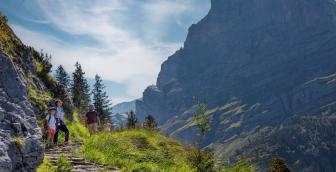
Bussalp via Spillmatten and Feld to Waldspitz


The starting point for this varied hike is Bussalp. Via the Feld viewpoint at over 2,160 metres above sea level and Rotenegg, the trail leads through rustic landscapes and numerous colourful seas of flowers to the destination of the hike – Waldspitz.
The Bussalp bus stop is the starting point for this hike. Once you have passed the inviting restaurant, the hiking signpost points up towards the viewpoint Feld. The wide path soon turns into a narrow hiking trail, which leads along the gurgling mountain brooks and lined with colourful mountain flowers up to the first intermediate destination: the viewpoint Feld. Shortly before that, a metal footbridge makes it easier to cross a small ditch. Your legs will be grateful for this, as they already have around 300 metres of altitude behind them. That's why you should take a short break at the viewpoint to enjoy the view and recharge your batteries.
The section down to Rothenegg reveals some natural beauty along the way. There is the rustic landscape with numerous large boulders between which the narrow hiking trail winds. Along the route, numerous flower species once again show their colourful blooms. Small brooks have to be crossed again and again. Then comes the actual descent down to Spillmatten. This trail section has a partially rough character. But hikers are rewarded again and again with the colourful splendour of the blue gentian or the yellow alpine anemone.
Then, it’s time for a little more relaxation for the legs. The hiking trail leads up and down through a fairytale-like forest with small hills and hollows. Several flower fields provide variety on the way towards Waldspitz. And suddenly the forest path joins the access road to the hiking destination. On the marl surface, which is now pleasant for tired legs and with a view of the magnificent mountain scenery, there are only a few minutes' walk to go before the Waldspitz bus stop and the restaurant of the same name come into view.
Overview plan summer

Bussalp mountain restaurant
The cosy mountain restaurant on Bussalp invites you to linger and relax. Treat yourself with culinary delights from the kitchen and enjoy the unique view of Eiger, Mönch and Jungfrau.
Waldspitz restaurant
Waldspitz restaurant welcomes you with a wonderful panoramic terrace and plenty of food and drink.
Prices
Line 126, Grindelwald – Bussalp (mountain line) /summer
Line 127, Grindelwald – Waldspitz (mountain line)
Timetable
You can find the timetable for lines 126 and 127 in the timetables.
Search for a connection
Directly plan your journey at the start of the offer.
Arrival journey
 to Bussalp
 from Waldspitz
Further information
Find more information about the journey here (hiking map, altitude profile and/or a video).

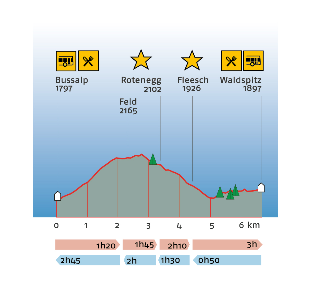
Erklärungstext zu Höhenprofil
The hike starts on Bussalp at 1,797 metres above sea level. There is a refreshment stop here. The path leads up to Feld at 2,165 metres above sea level. At this point just over 2 kilometres of the 6.7-kilometre route have been completed. You can expect a walking time of one hour and 20 minutes. The route then continues slightly uphill to the highest point of the hike and then down to the first highlight, Rotenegg at 2,102 metres above sea level. The 3-kilometre route takes about one hour and 45 minutes to complete. The trail continues down to the second highlight of the hike, Fleesch, at 1,926 metres above sea level. The route is almost 4.5 kilometres long and takes 2 hours and 10 minutes to complete. Then it continues up to the destination of the hike, Waldspitz, at 1,897 metres above sea level. There is a refreshment stop here. The entire hike is expected to take 3 hours. The hike cannot be interrupted en route, as there are no stops along the entire route. Hiking in the opposite direction takes 50 minutes to Fleesch at 1,926 metres above sea level, one hour and 30 minutes to Rotenegg at 2,102 metres above sea level and 2 hours to the highest point of the hike to Feld at 2,165 metres above sea level. Plan a total of 2 hours and 45 minutes for the entire hike to Bussalp at 1,797 metres above sea level.
Plan and organise your journey
Have the entire hike compiled as a PDF or download the GPS file.
Our tip: Open the GPS file conveniently on the go with the hiking planner app from the Bernese hiking trails.
Share the journey with your friends.