Navigieren auf STI Bus AG
Sprunglinks
Suchbox
Hauptnavigation

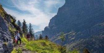
Grosse Scheidegg to Schwarzwaldalp


The starting point for this easy and wonderful hike is Grosse Scheidegg. The hiking trail offers everything hikers could wish for: a beautiful route with few challenges, wonderful insights into the flora and fauna, wild watercourses and marvellous views of the nearby and distant mountains.
From the bus stop on Grosse Scheidegg in the direction of Gratschärem, the first thing to do is to warm up. On a marl surface, the trail leads along alpine meadows with intensely blue gentians to this waypoint. From there, the route conditions remain the same in the direction of Scheidegg Oberlägeri. As are the faithful companions: the majestic Wetterhorn and the rugged Engelhorn group. Only on this section streams cross the hiking trail. From the waypoint at 1,950 metres above sea level, the route soon changes. Along Cherrhubel, the path becomes a narrow track. It leads through wonderful meadows with a magnificent splendour of flowers and through small wooded areas. Of course, the blue gentian dominates here too, but you can also marvel at the rare white gentians. The real highlight follows a short time later; it is the rest area before the descent to Pfanni. Here you can enjoy a phenomenal view over Schwarzwaldalp as far as to Titlis (Mountain in Central Switzerland) on the benches in front of a simple wooden shelter with a barbecue area.
Then the steep descent to Pfanni begins. The narrow hiking trail leads over sections of stairs and small wooden walkways. You can see and hear the roaring Pfannibach stream from afar, which will shortly accompany the hikers a little later. Once you reach the waypoint downhill, it's time for your legs to relax again. On a marl surface, the route descends along alpine meadows and mountain huts in long curves towards Schwarzwaldalp. The bus stop is right next to the Chalet-Hotel Schwarzwaldalp, where hungry people can enjoy various local specialities while waiting for the postbus.
Overview plan summer

Grosse Scheidegg mountain restaurant
The Grosse Scheidegg mountain restaurant will delight you with its panoramic views. It is the ideal starting point for family, hiking, business and club excursions. Indulge yourself in the mountain restaurant in the heart of the Bernese Oberland mountains.
Chalet Schwarzwaldalp
Let yourself be spoilt in the lovingly run restaurant with delicious and genuine cuisine. Whether it's coffee and cake in the afternoon, something savoury or a stylish dinner – at Chalet-Hotel Schwarzwaldalp you will find what your heart desires.
Prices
Line 128, Grindelwald – Grosse Scheidegg – Schwarzwaldalp (mountain line)
Timetable
You can find the timetable for line 128 in the timetables.
Search for a connection
Directly plan your journey at the start of the offer.
Arrival journey
 to Grosse Scheidegg from Schwarzwaldalp
Further information
Find more information about the journey here (hiking map, altitude profile and/or a video).

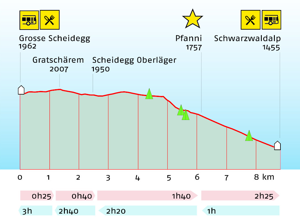
Erklärungstext zu Höhenprofil
The hike starts at Grosse Scheidegg at 1,962 metres above sea level. There is a refreshment stop at Grosse Scheidegg. The path leads slightly upwards to Gratschärem at 2,007 metres above sea level. This is the highest point of the hike. About 1 kilometre of the 8.8-kilometre route is already completed here. A walking time of 25 minutes is to be expected. The route goes then gently downhill to Scheidegg Oberläger at 1,950 metres above sea level. The route is almost 2.5 kilometres long and takes 40 minutes to walk. The path leads down to the highlight of the hike, Pfanni, at 1,757 metres above sea level. The route is almost 6 kilometres long and takes an hour and 40 minutes to walk. It then goes downhill to its destination, Schwarzwaldalp, at 1,455 metres above sea level. There is a re-freshment stop here. The entire hike is expected to take 2 hours and 25 minutes. The hike cannot be inter-rupted en route, there are no stops along the entire route. Hiking in the opposite direction takes one hour to Pfanni at 1,757 metres above sea level, two hours and 20 minutes to Scheidegg Oberläger at 1,950 metres above sea level and two hours and 40 minutes to the high-est point of the hike, Gratschärem at 2,007 metres above sea level. Plan a total of 3 hours for the entire hike to Grosse Scheidegg at 1,962 meters above sea level.
Plan and organise your journey
Have the entire hike compiled as a PDF or download the GPS file.
Our tip: Open the GPS file conveniently on the go with the hiking planner app from the Bernese hiking trails.
Share the journey with your friends.